


Construction surveying, new software and drones
22 February 2022
The construction surveying sector is embracing the use of digital tools such as drones. Staying current with constantly evolving technology is the only way to keep up with the ever-present pressure to increase productivity, reports Katherine Weir
One of the most precious resources in construction is time. The digitalisation and automation of surveying – traditionally a time-consuming task – is helping reduce the time spent surveying; without the role losing its vital place in the construction industry.
Drones are an additional tool in the surveyor’s toolbox. Geared with the right equipment, software and services, surveyors are branching into new areas providing measurements, positioning and the data needed for a variety of construction services.
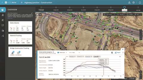 HCSS Aerial states that using drones for surveying is now the industry standard.
Why are drones used in construction?
Rateb Almasri, senior product manager at drone software firm, HCSS Ariel, said, “Manufacturers of drone technology are working hard to develop new designs for longer flights and increased capabilities.
“Drones are up to five times faster to perform surveys than traditional methods. They can be used over any terrain. Using drones for surveying is now the industry standard; reducing time on site, increasing safety for difficult terrain, reducing ‘boots on the ground’ and lowering costs.”
The manufacturer’s drone software is said to allow contractors to do more with less and automate numerous surveying processes. Almasri said, “For example, you can track material volumes and quantities; manage stockpiles of materials, like dirt or sand for an earthwork project; you can easily determine quantities on hand – used and needed. You can also gauge the rate at which materials are used by automatically calculating the quantity change from flight to flight.”
These reports by software companies are typically made available within 24 hours, allowing for more data-driven decisions and improved communication with project stakeholders.
New technology in surveying
Casey Cyrus, director of product management for Trimble Site Positioning Systems, said, “The biggest push in surveying today is around maximising the use of survey data, both for the current need and for analysis of the project’s health into the future. Understanding and using data collected daily, weekly and throughout the project lifecycle helps in bidding new jobs and finding additional cost savings along the way.
“When it comes to the continued use of data, automation is the gift that keeps on giving. Data collected today – either manually or with automated survey systems – can be uploaded to systems for further automation. A ground-based scanning solution, for example, can be deployed to collect its surrounding environment and can scan the progress hourly, feeding this information to the cloud where it is consumed in various ways, such as for automated progress reporting in the office or used by operators in the field to see the current state of the surface.”
 Drone software from HCSS Aerial is said to allow contractors to do more with less and automate numerous surveying processes.
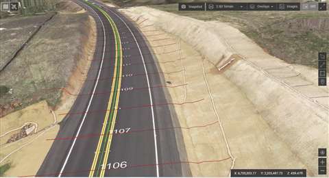
Cyrus states that a turning point for Trimble’s construction customers was the introduction of the DJI Phantom 4 RTK. Prior to that, multi-rotor drones with PPK capability were extremely costly and required expertise to operate correctly.
“Trimble Stratus software changed that by using an inexpensive PPK drone and workflows that enabled confidence in the results, from independent checks to the end deliverables.”
The pressure is on for surveying service providers to adapt new service offerings and integrate more efficient processes and technologies. Craig Hill, vice president of geomatics and reality capture marketing and services at Leica Geosystems, part of Hexagon, said, “With increasing needs to design, plan, construct and maintain better and quicker, there will be increasing opportunities for surveying businesses providing services to construction companies.”
The company’s GS18 I captures images and measures hundreds of points within minutes without needing to physically reach the point. There’s also Leica Geosystems’ most recent unmanned aerial vehicle (UAV) technology, the BLK2FLY, which captures building exteriors, structures, and environments to create 3D point clouds while flying.
“Before the launch of this product, UAV technology was mostly based on photogrammetry – now, the BLK2FLY is the world’s first UAV with fully-integrated LiDAR,” said Hill. “It is an autonomous flying laser scanner with advanced obstacle avoidance for easy reality capture from the sky.”
Automation in surveying
Topcon Positioning Group claims that, with automated technology, it’s now possible to verify up to 99% of as-built construction accuracy in a fraction of the time it would traditionally take to spot check just 5% of the build.
Leighton Davies, regional sales manager for geomatics at Topcon Positioning Group, said, “In surveying, the main area of automation we see is with data gathering, with scanners and hybrid total stations able to collect data efficiently and share it with digital workflow solutions; all of which can be controlled remotely. This combination offers a digitalised future for surveying, with the cloud able to communicate data in easy-to-understand forms across entire project teams and with clients.
 Maximizing the use of survey data, both for the current need and for analysis of the project’s health into the future is the biggest push in surveying today, says Trimble Positioning Group.
“However, with surveying being such a traditional part of the construction process, there are many businesses and whole territories that are still using older methods, including planting stakes in the ground. It’s important that the entire industry is aware of the possibilities of advanced solutions, especially one’s using automation, as they really can revolutionise ways of working.”
Davies also impressed the importance of those working in surveying understanding that the job is changing.
In terms of technology in this sector, there have been suggestions that other software may mean that, in the future, perhaps drones won’t be needed. Is there truth in this?
“Drones are really just getting started and are here to stay,” said Burcin Kaplanoglu, vice president, Oracle Industries Innovation Lab. “They can capture tons of images that would not otherwise have been possible and feed that data back into other intelligent construction and surveying systems.”
Kaplanoglu adds that another exciting development is laser scanning. “In 2020, we were busy building the Oracle Industries Innovation Lab outside of Chicago, USA. As part of the build, we collaborated with Faro Technologies to enable a semi-autonomous workflow of laser scanning with the integration of Boston Dynamics Spot robot.
“This workflow carried the laser scan data into a common data environment within Oracle Construction and Engineering project management solutions. This enabled project teams to visualise the data in Reconstruct, which does remote quality control and progress monitoring. This is a real-world example of how these technologies changed the surveying and build process at a time where keeping crews remote was never more important.”
What type of drones are used in construction?
Surveying equipment and software company Microdrones state that drones are an additional tool for surveyors. They don’t replace traditional methods nor manned aircraft but complement those tools. Mike Dziok, vice president, global marketing at Microdones, said, “Depending on the project, drone survey equipment may make a job easier, safer or richer in data collection points compared to these methods.
“Increasingly, survey and construction companies are finding drone survey equipment to be a very effective and powerful tool. As software continues to develop and evolve, it doesn’t seem that software would replace drones, but rather increase the speed and efficiency of processing the data collected by drones.”
Drone technology in construction surveying has been historically expensive. Has this improved over time? Dziok said that the technology for drones, sensors, software and tools is constantly evolving and improving, along with becoming more affordable.
“In 2020, we rolled out our mdaas (Microdrones as a service) programme that works to meet a multitude of customers where they need to be today in terms of adopting this technology. Through this, users have the option to buy drone survey equipment or to rent it. In terms of software and data processing they can subscribe or do a ‘pay as you go’ plan. Depending on the volume of data they are collecting and processing, there is a plan that makes sense.”
How much do drones cost?
Photogrammetry software company Pix4D says that hardware pricing is coming down, making things like mobile mapping and laser scanning much more attainable for the average survey and construction company.
Ryan Sweeney, product manager for PIX4Dcatch hardware, said, “There have also been a lot of great new entries into the affordable GNSS receiver space as well. Newer, better software to manage and take advantage of captured data from providers like Autodesk, Skyward, and Pix4D has been a brilliant new addition to the surveying world.
“Cloud services to make all this data more accessible and easier to use for everyone involved have been a very welcome development for many surveyors, and those on the more cutting edge are even starting to bring in AR/VR headsets to help get the best possible view of their projects.
“The newest, and one of the most exciting developments, is the evolution of mobile devices which means – with the right application – phones can now measure distances with LiDAR too. When combined with cloud services and photogrammetry, it means we can get accurate 3D models on-site in a few minutes.”
To enhance results alongside drones, or to even be used in place of drones, Pix4D’s new software – mobile app PIX4Dcatch – uses a phone or tablet camera (and LiDAR sensor on supported devices) to take photos with the correct amount of overlap necessary for reconstruction, the company said. Instead of sending a drone up to survey a pile, you walk around it with your phone, upload it to the cloud, and get the stockpile quantity in a few minutes.
Sweeney states, “It’s a sector that is seeing mass automation, and when that is combined with the knowledge of surveyors, it is creating a new way for construction to move into the future.”
Concept-X: No human intervention necessaryAt the Consumer Electronics Show (CES) 2022 – held in Las Vegas, US, in January – Hyundai Construction Equipment and Hyundai Doosan Infracore presented its selection of ‘Smart Construction’. In relation to automated/unmanned construction sites, the Concept-X project ‘is a comprehensive control solution that measures and analyses the topography of the construction sites by using 3D drone scanning devices and creates operation plans based on the topography data.’ The company also claims that this is the first smart construction solution that ‘successfully demonstrated the entire process from the measurement to the use of equipment to be automatically operated without any human intervention.’ There are plans to commercialise this solution by 2025, and a sequential market release is expected by completing verification in phases of individual technologies such as topography measurement using drones. |
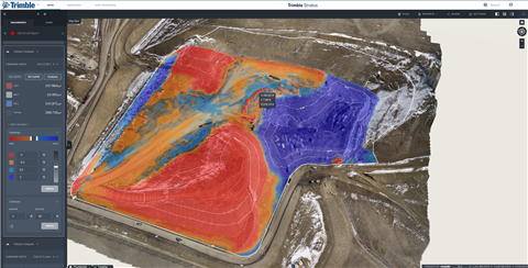
Digital site visulation keeps project on trackNCC, the Scandanavian-based building and construction firm, recently undertook rebuilding the Drammen railway station. Part of the new 10km double-track from Drammen to Kobbervikdalen, the completed railway will provide one and a half million inhabitants in eastern Norway with shorter travel times and more departures. The project includes building platforms, pedestrian underpasses, a waterfront promenade and parts of a new city bridge spanning the track area, all while the railway is still in operation. Communication between many subcontractors about a worksite this large meant the project was prone to miscommunications, disputes and delays. NCC’s Infrastructure team elected to tackle these issues before they had an opportunity to develop. Leveraging Trimble Stratus, powered by Propeller, NCC shares up-to-date, survey-grade digital maps of the entire site with all teams. The map, updated each time NCC surveyed with a drone, shows a visual timeline of data that’s inarguable, leading to a significant reduction in disputes across the project. Maria Melfald, Head of Surveying, NCC, says, “Surveying via drones improves efficiency, but we also save an average of four-six hours in direct processing time for every survey processed through the platform, as well as cut down the results turnaround from three-four weeks to just a few days.” |
STAY CONNECTED


Receive the information you need when you need it through our world-leading magazines, newsletters and daily briefings.
CONNECT WITH THE TEAM